Seismic Activity in Pennsylvania
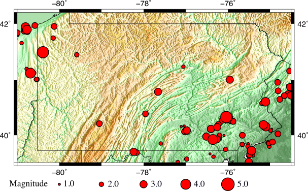
Earthquakes in Pennsylvania occur primarily in the northwestern and southeastern portions of the state. However, earthquakes have also occurred sporadically in other parts of Pennsylvania. While the majority of the earthquakes are small, there have been moderate size earthquakes in the past, such as the September 25, 1998 magnitude 5.2 Pymatuning earthquake. In southeastern Pennsylvania, the majority of earthquakes have occurred in the Lancaster Seismic Zone (LSZ) (Armbruster and Seeber, 1987). The LSZ is located along the western edge of the Newark Basin Seismic Zone (NBSZ), which is a broader seismic zone that extends from the LSZ through New Jersey and into New York (Armbruster and Seeber, 1987). The NBSZ borders the Newark Basin, which formed by Mesozoic rifting (Ratcliff et al, 1971; Armbruster and Seeber, 1987). The western side of the NBSZ is marked by the Ramapo fault system, which strikes to the northeast, dips to the southeast, and extends from southeastern New York through southeastern Pennsylvania (Armbruster and Seeber, 1987). Several felt earthquakes have occurred in the area of the LSZ and NBSZ, such as the April 23, 1984 magnitude 4.1 Marticville earthquake and the January 16, 1994 magnitude 4.6 Cacoosing Valley earthquake (Seeber et al., 1998). The map below shows earthquakes in Pennsylvania from January 1970 to June 2015 reported by the U.S. Geological Survey.

In addition to earthquakes, there are a large number of seismic events caused by mine blasts throughout the state. These blasts primarily occur in the bituminous and anthracite coal mining regions of the state and in industrial mineral quarries.
An in-depth study of seismicity in Pennsylvania that occurred between February 2013 and June 2015, completed by Penn State for the Bureau of Topographic and Geologic Survey, can be downloaded below.
References
- Armbruster, J.G. and L. Seeber. “The 23 April 1984 Martic Earthquake and the Lancaster Seismic Zone in Eastern Pennsylvania” Bulletin of the Seismological Society of America 77.3(1987) 877-890.
- Ratcliff, Nicholas M. “The Ramapo Fault System In New York and Adjacent Northern New Jersey: A Case of Tectonic Heredity.” Geol Soc America Bull Geological Society of America Bulletin 82.1 (1971): 125.
- Seeber, L., J. G. Armbruster, W. Kim, and N. Barstow. “The 1994 Cacoosing Valley Earthquakes near Reading, Pennsylvania: A Shallow Rupture Triggered by Quarry Unloading.” Journal of Geophysical Research 103.B10 (1998): 24505.